What is he doing now? Attaching a GPS unit to his wrist? For skydiving?
Well I’ll never get lost. hahah. A few months ago I found out about [Tracking Derby](http://www.trackingderby.com/). Mount a GPS (like the Garmin Foretrex 201), record your jump, upload it to their service where they [show](http://www.trackingderby.com/en/trace_view_training_2329_meters.php) it. The overall thrust of the group is competitions but for a lowly diver like myself it’s another vantage point with which to see what I’m doing, where I’m going, and replay for learning more of the experience.
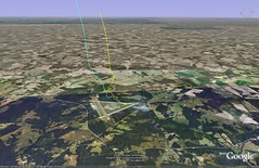
Tracking Derby will export your data to [Google Earth](http://earth.google.com) which was really neat to see. The shot below (click [through](http://www.flickr.com/photos/ciordia/425990865/) for a better view) is of Chester, SC–the municipal airport, and [Skydive Carolina](http://www.skydivecarolina.com). My 19th jump is depicted in the yellow line, my 20th the blue. Both start tracking around 8-9k feet. I haven’t figured out the knack for getting signal in the Otter yet. Most of what you see is the last moments of free fall then transition into a canopy descent/landing. This is pretty usual for me; I hang out at the end of the main runway until 1-2k then weave into the traffic pattern.
Even if you don’t understand it at the time of exposure the more facets you give yourself to explore your world the more you will reap from it. Looking at my altitude data from my altimeter data-logger has shown how I synchronize with coaches, how my flat tracks are coming to smooth transitions in velocity. You shouldn’t get lost in what is important with each thing you do, but having something to reflect on in hindsight is really special.